Traffic Image Analysis
2024-11-18
How advanced image analysis is contributing to optimize urban mobility?
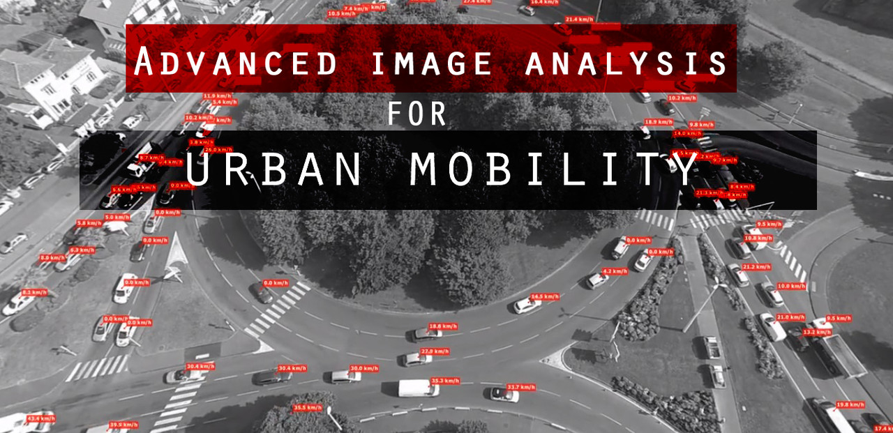
When carrying out a complex traffic study, it may be difficult to map the entire traffic situation, especially with traditional methods (CCTV cameras, radars, inductive loops or even manual counting etc.). Using a solution in form of traffic research from air with a drone and advanced computer vision software, all movements are recorded down and analyzed to the smallest detail for unlimited data. In addition to highways, roundabouts, intersections and other traffic nodes, the system is also suitable for parking areas, events, station environments or terminals, city centers and much more.
The benefits of traffic research from the aerial video using advanced software for image processing are e.g.:
- Accurate and detailed data about traffic from the bird’s eye perspective:
- complete trajectory and moving patterns of each traffic participant
- complex OD- matrix – vehicle counts, turning movements
- speed and acceleration profile of each vehicle
- vehicle classification into categories (car / heavy vehicle / bus, / motorcycle etc.)
- travel time, stationary time (queuing time)
- advanced heatmaps based on the velocity, acceleration, traffic low
- safety analysis (detection of near accidents based on calculation of Time to Collision [TTC], detection of risky situations or inappropriate driving behavior
- Reliable, detailed research without influencing traffic behavior (inconspicuous solution)
- Ultimate traffic research, almost without a human intervention – based on the machine learning and DNN
- Powerful tool which can improve traffic safety
USECASES
A) Safety Studies
There are various applications of the advanced image analysis, a great added value is the possibility to evaluate the location in terms of safety. The analysis can e.g. map traffic and movements near the schools or kindergartens during the morning rush hour when many students arrive at school at the same time. The analysis gives a complex overview, where potential conflicts between cyclists, pedestrians and cars may happen.
Based on the analysis and its outputs, it is easier to formulate some changes which should be adopted by schools to protect the safety of schoolchildren. It can also lead to better decision making done by municipalities, whether to build a new crossing or add some safety features or how it is possible to change an established behavior that is dangerous or inappropriate.
Safety analysis of an important city corridor can help to identify strategies on how to create a safe and attractive pedestrian environment, a robust infrastructure for bicyclists, and linkages between residential areas and the shops, parking areas etc.
Based on the detailed trajectory of each traffic participant extracted from the video, the Safety analysis can bring interesting results and overview about some dangerous situations and inappropriate driving behavior:
Aggressive driver behavior / Offensive lane changing / Short following distances / Collision-prone traffic hub areas.
B) Study of bicycle lanes and pedestrian crossing in city centers
Many cities nowadays try to change the traffic habits and move citizens from cars to bicycles and public transport. With such desire, large space problems can rise in connection with parking spaces for bicycles. Sometimes, the bike rails are crowded and illegally parked bikes fill up the street scene and create dangerous pedestrian situations. Such situation occurred for example in city of Alborg in Denmark, where a comprehensive study of a public area was carried out.
In order to find the optimal location of bicycle parking facilities, the movement patterns of each traffic participant, especially pedestrians and bicycles, were analyzed using advanced image processing software. Based on these patterns, detailed data, statistics and trajectories information, a complex study was carried out, examining where it will be possible to implement more parking places for bicycles in and around the square, resulting with a proposal for how the space can be furnished – offering more space for bicycle parking and rest areas for pedestrians.
The analysis has also resulted in illustrations of average speed of pedestrians in this square. The data were used to design areas where pedestrians typically stop and where there may be a need for seating (e.g. near the bus station), moreover, these information and data are extremely valuable for a safety study in a given zone, which can be adopted by the municipality to make some changes in order to increase the safety of pedestrians and bicycles in analyzed area.
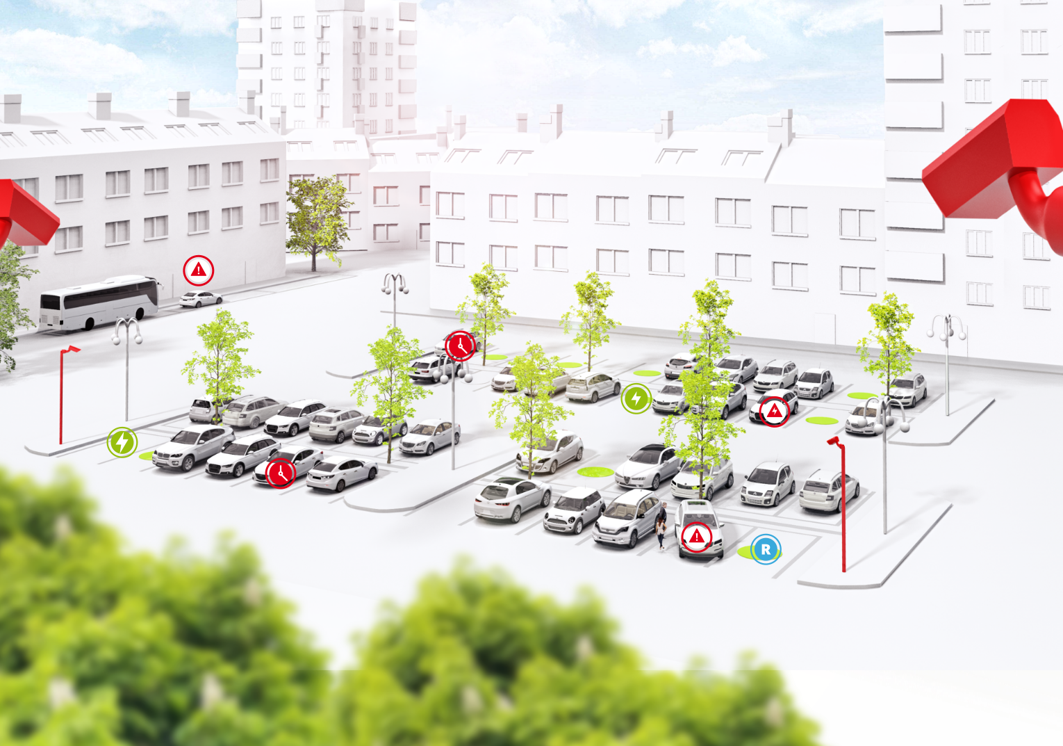
C) Study of the parking lots utilization
For many cities all around the world, parking is a major source of revenue but also a primary cause of traffic congestion and sometimes a true nightmare for drivers. In the last few years, many smart parking solutions have been conceived and some of them implemented, such as embedded sensors in the ground that relay to a smartphone when a parking space is available.
But instead of tearing up the asphalt to build in these costly sensors, what if cities used drones to monitor parking availability? Moreover, there is a huge future potential for self-parking autonomous vehicles, that lots of car companies are developing nowadays. On the infrastructure side, there still needs to be information made available to the cars so they know where to park. Solutions such as DataFromSky can easily help with that – detect a free parking spot and easily navigate the autonomous car to that place.
The use of drones is becoming increasingly useful when conducting parking studies, utilizing far less manpower, while collecting more comprehensive data compared to standard methods. The drone video survey can provide additional insights into site conditions that would not be captured otherwise, such as queueing or illegal parking.